The measurement of a nation’s coastline is not a static geographic fact but a function of the scale at which it is measured. This phenomenon, known as the Coastline Paradox, dictates that as the unit of measurement decreases, the total length of the coastline increases toward infinity. Standard rankings of the world’s longest coastlines often fail because they conflate raw distance with geographical complexity. To understand which nations truly dominate the maritime interface, one must analyze the interplay between tectonic activity, glacial erosion, and the fractal dimension of the land-sea boundary.
The Fractal Dimension: Why Rankings Vary
The discrepancy between various datasets—such as the CIA World Factbook and the World Resources Institute—stems from the "ruler" used. A 100-kilometer ruler ignores the indentations of a small bay; a 1-meter ruler accounts for every boulder. This is quantified by the Fractal Dimension ($D$), where $D$ represents the complexity of a curve. For a perfectly straight line, $D=1$. For a coastline like Norway’s, $D$ can exceed $1.5$.
The following nations represent the global elite of maritime reach, categorized by the geological mechanisms that created their vast perimeters.
The Primary Tier: Continental Giants and Archipelagic Networks
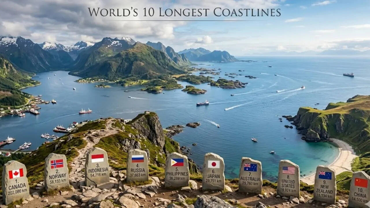
1. Canada: The Glacial Outlier
Canada possesses the longest coastline in the world, exceeding 202,000 kilometers. The primary driver here is the Arctic Archipelago, a cluster of over 36,000 islands. The geological history of this region is defined by post-glacial isostatic rebound. During the last glacial period, the weight of the ice sheets depressed the earth's crust; as the ice melted, the land began to rise, creating a highly fragmented and intricate network of channels and inlets.
The Canadian coastline is not a contiguous defensive or economic perimeter but a decentralized logistical challenge. The complexity is concentrated in the North, where the fractal nature of the coastline is highest. If Canada’s coast were straightened, it would wrap around the equator roughly five times.
2. Norway: The Fjords of the North Atlantic
Norway’s ranking is the most significant victim (or beneficiary) of the Coastline Paradox. While its mainland coast is relatively modest, the inclusion of its fjords and over 200,000 islands pushes its total length to approximately 58,000 kilometers (excluding islands) or over 100,000 kilometers when including them.
The mechanism at work is glacial carving. Deep U-shaped valleys, carved by glaciers during the Pleistocene, were flooded by rising sea levels to create fjords. These inlets dramatically increase the land-sea interface without increasing the nation’s linear north-south extent. From a strategic perspective, this creates a "Deep Water Coast" that allows for massive maritime infrastructure in sheltered, inland-reaching waters.
3. Indonesia: The Archipelagic Superstate
Indonesia represents the world’s largest archipelagic state by volume of islands (over 17,000). Unlike Canada or Norway, Indonesia’s coastline is driven by tectonic and volcanic activity. Situated on the Pacific Ring of Fire, the country is a collection of volcanic peaks rising from the sea floor.
The coastline, estimated at 54,716 kilometers, provides a unique economic variable: the Exclusive Economic Zone (EEZ). Because the islands are spread across three time zones, the ratio of coastline to landmass is exceptionally high, granting Indonesia jurisdiction over vast oceanic resources that far outweigh its terrestrial footprint.
4. Russia: The Arctic and Pacific Frontier
Russia’s coastline, roughly 37,653 kilometers, is defined by its massive longitudinal span. Unlike the fractal complexity of Norway, Russia’s northern coast is characterized by broad, sweeping shelves and deltaic systems, such as the Lena and the Ob.
The strategic value of this coastline is currently undergoing a phase shift due to thermal forcing. As Arctic sea ice retreats, the Northern Sea Route (NSR) is transforming from a frozen barrier into a viable transit corridor. This effectively "activates" thousands of kilometers of coastline that were previously economically dormant.
The Secondary Tier: Stability and Erosion
5. The Philippines: High-Density Archipelagic Complexity
With 7,641 islands, the Philippines follows a similar logic to Indonesia but on a denser scale. Its 36,289 kilometers of coastline are a byproduct of the Philippine Mobile Belt. The complexity here is found in the coral reef systems and limestone karst topographies, which create highly irregular, jagged shorelines that are difficult to map at low resolutions.
6. Japan: The Volcanic Arc
Japan’s 29,751 kilometers of coastline are the result of its position as a volcanic island arc. The four main islands (Honshu, Hokkaido, Kyushu, and Shikoku) are supplemented by nearly 7,000 smaller islands. The coastline is characterized by Ria coasts—submerged river valleys—particularly on the eastern seaboard, which provide the deep-water harbors necessary for Japan’s industrial maritime economy.
7. Australia: The Continental Monolith
Australia provides a counter-point to the archipelagic models. Its 25,760 kilometers are largely contiguous. The lack of recent glacial activity means Australia lacks the fjords of the northern hemisphere. Instead, its coastline is shaped by long-term marine erosion and the Great Barrier Reef system. The northern coast is significantly more complex due to tidal flats and mangrove systems, whereas the Great Australian Bight in the south is a relatively smooth, high-cliffed interface.
8. The United States: The Three-Ocean Interface
The U.S. coastline (approximately 19,924 kilometers) is split across the Atlantic, Pacific, and Arctic oceans. The primary driver of complexity is Alaska, which accounts for more than half of the total U.S. coastline. The Alaskan coast mimics the Norwegian model of glacial fjords and archipelagic fragments, while the Atlantic coast is defined by barrier islands and lagoons, which are dynamic systems that shift annually due to sediment transport and hurricane activity.
The Structural Drivers of Coastline Length
To move beyond a simple list, we must categorize these nations by the Geomorphological Forcing Agents that determine their coastal density.
| Mechanism | Primary Effect | Representative Nation |
|---|---|---|
| Glacial Abrasion | Deep fjords, high fractal dimension | Norway, Canada, Chile |
| Volcanic Orogeny | Fragmented archipelagos, high island count | Indonesia, Philippines, Japan |
| Tectonic Rifting | Linear, stable shorelines, low complexity | Africa (General), Australia |
| Sedimentary Deposition | Deltaic expansion, low-lying marshes | Vietnam, United States (Gulf) |
The Cost Function of Coastline Management
A longer coastline is not an inherent economic advantage. It introduces a Surveillance Burden. The cost of monitoring a coastline for illegal fishing, smuggling, or environmental degradation scales with its complexity, not just its length.
- The Friction of Distance: In archipelagic states like Indonesia, the "broken" nature of the coastline increases the cost of internal trade, requiring a robust "sea bridge" infrastructure.
- The Exposure Variable: Complex coastlines are more vulnerable to sea-level rise. A fjord-based system may have higher elevation protection, whereas a delta-based system (like Russia or the US Gulf) faces existential risk from a mere 1-meter increase in sea level.
The Strategic Play: Capitalizing on the Land-Sea Interface
Nations with high coastline-to-landmass ratios must pivot their economic strategies from terrestrial extraction to Blue Economy frameworks. The following tactical shifts are mandatory for high-ranking coastal nations:
- Fractal Infrastructure Mapping: Traditional GPS mapping fails in high-complexity zones like the Norwegian fjords or the Canadian Arctic. Implementing high-resolution LiDAR bathymetry is the only way to secure safe navigation and resource extraction.
- Decentralized Port Systems: In nations like the Philippines or Japan, a "Hub and Spoke" maritime model is less efficient than a "Mesh Network" of smaller, automated ports that can handle the jagged nature of the coast.
- Climate Adaptation via Natural Buffers: For nations like the US and Australia, the focus must shift from hard engineering (sea walls) to "Living Shorelines." The complexity of the coast should be used as a tool to dissipate wave energy through restored mangroves and reef systems.
The measurement of a coastline is ultimately a measure of a nation’s potential for global integration. Those that understand the mathematical reality of their borders—accepting that they are infinite in detail but finite in resource—will dominate the maritime century. The final strategic move for any coastal power is the transition from defending a line to managing a fractal space.